
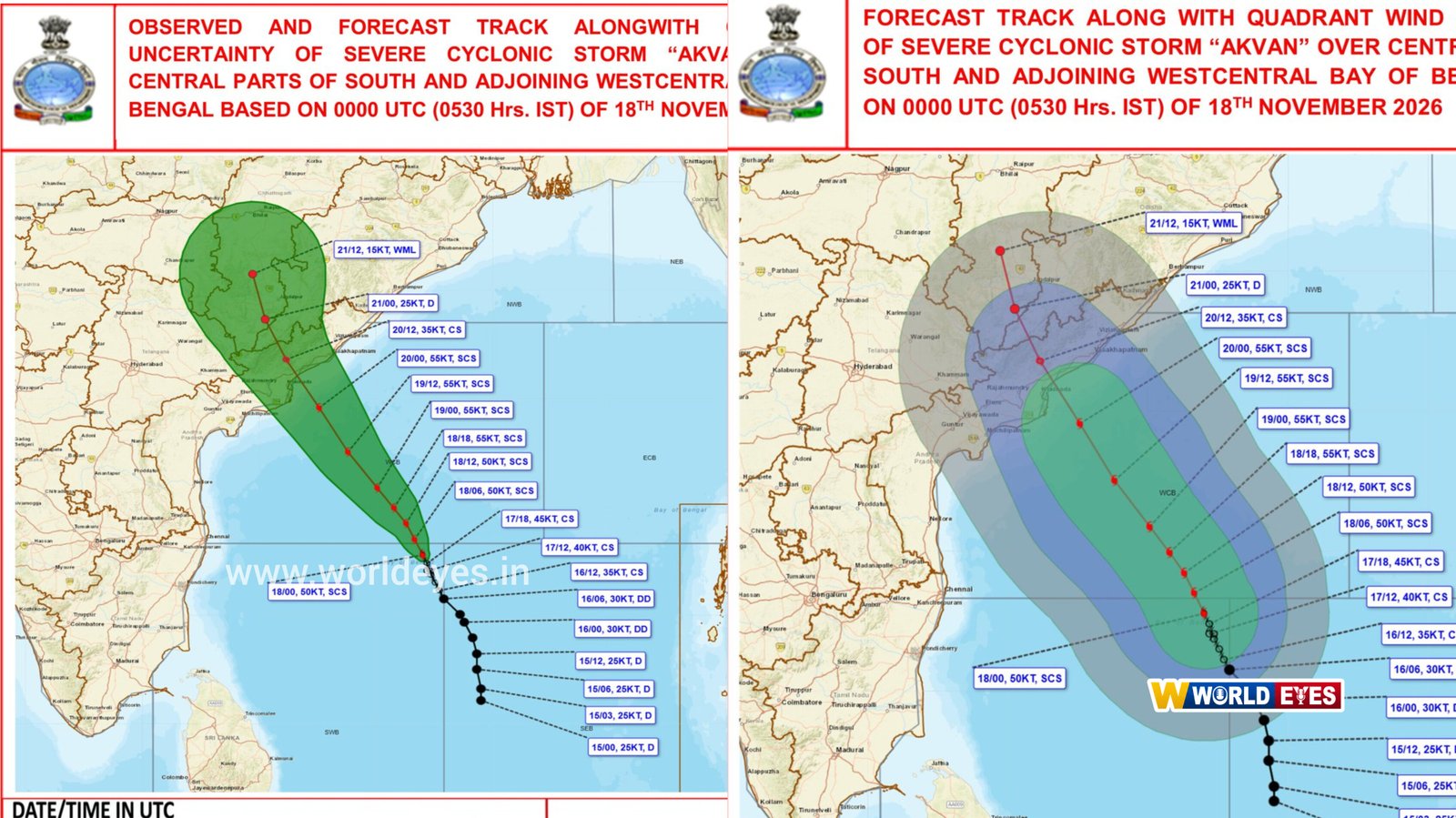
Odisha: Cyclone Akvan is moving at an unusually slow pace while gradually gaining strength, raising concerns over its potential impact on Odisha, particularly the southern districts. The storm has reportedly moved at just 3 kmph over the past six hours, remaining nearly stationary in the same region until 2:30 AM on Wednesday.
According to the latest weather projections, Cyclone Akvan may intensify into a severe cyclonic storm by Wednesday. It is likely to strengthen further into an extremely severe cyclonic storm by the evening of November 19.
Andhra Pradesh Landfall Expected on November 20
The cyclone is likely to make landfall along the Andhra Pradesh coast between Nellore and Visakhapatnam by noon on November 20. At the time of landfall, wind speeds are expected to reach 120–130 kmph, with gusts potentially touching 145 kmph.
However, the latest projected track suggests that Odisha could face significant impacts as the storm moves inland after landfall.
South Odisha Under Increased Threat
According to the revised forecast, Cyclone Akvan may move through Malkangiri after crossing the Andhra Pradesh coast, potentially retaining severe cyclonic intensity. Southern Odisha districts, including Malkangiri, Koraput, Nabarangpur and Nuapada, are likely to be among the areas at risk.
The new forecast has raised concerns as the cyclone may retain greater intensity while moving through southern Odisha, unlike earlier projections that suggested it would weaken into a deep depression before entering the state.
Cyclone Track and Intensity Forecast Revised
Earlier weather projections indicated that Cyclone Akvan would weaken considerably while moving across Odisha. However, the latest track and intensity estimates suggest a potentially stronger system moving north-northwestwards.
The cyclone is expected to intensify into a severe cyclonic storm by Wednesday morning and could become an extremely severe cyclonic storm by Thursday morning. Landfall is projected around midday on November 20, after which the system may move inland towards Malkangiri, raising concerns over heavy rainfall, strong winds and possible disruption across southern Odisha.
Authorities and residents in the vulnerable districts are likely to remain on alert as the cyclone's track and intensity continue to evolve.
Reader Discussion (0)
Leave a Reply
Your email address will not be published. Required fields are marked *