
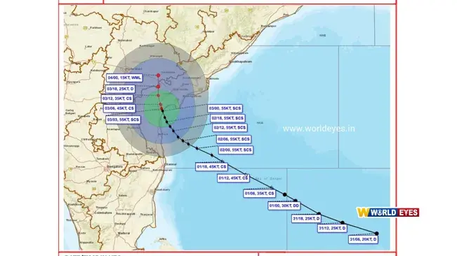
Severe Cyclone Murasu has made landfall along the South Andhra Pradesh coast near Ongole at around 1 AM on Tuesday, November 3, according to the information provided in the report.
At the time of landfall, the wind speed was estimated at 100 to 110 kilometres per hour, with gusts reaching up to 120 kilometres per hour. Prakasam district has been among the worst-affected areas in Andhra Pradesh.
The India Meteorological Department has issued a red alert for Nandyal, Tirupati and Palnadu districts due to the possibility of extremely heavy rainfall. An orange alert remains in place for 11 other districts, including Prakasam, Nellore, Bapatla, Guntur and Krishna.
The outer bands of the cyclone have also triggered heavy rainfall in Puducherry and northern Tamil Nadu since midnight, disrupting normal life. With sea waves expected to reach heights of 1.5 to 2 metres, low-lying coastal areas of Bapatla, Krishna and Prakasam districts face the risk of inundation.
According to the IMD forecast cited in the report, Cyclone Murasu is expected to move west-northwestwards over land and gradually weaken after remaining a severe cyclonic storm until Tuesday morning.
Strong winds of 70 to 80 kilometres per hour, with gusts reaching 90 kilometres per hour, are likely over parts of coastal Andhra Pradesh, Rayalaseema and Telangana until Tuesday afternoon.
The impact of the cyclone is also expected to be felt in southern Odisha, Telangana and Chhattisgarh, where heavy rainfall is likely over the next 24 to 48 hours.
Bad weather has disrupted air and rail services. Around 30 domestic flights have reportedly been cancelled at Chennai, Vijayawada, Visakhapatnam and Tirupati airports, while the operations of nine major trains have been suspended. More than 30,000 people have reportedly been evacuated from vulnerable areas and shifted to safer shelters.
Reader Discussion (0)
Leave a Reply
Your email address will not be published. Required fields are marked *